The diversity of the GOES-R user community is reflected in the wide variety and applications of GOES-R series data and products. Larger institutional users can exploit the increases in spectral, temporal, and spatial resolution and assimilate radiances for use in prediction models, increasing the timeliness and accuracy of forecast products. GOES-R data will be used in real time for critical life and property forecasting and warning applications primarily by the National Weather Service, where these users will be able to monitor the rapid development and interaction of severe storms. Other smaller public and private sector users will be able to obtain GOES-R data through their own Earth stations, or through terrestrial network distribution. Learn more about user systems.
GOES-R data products are available using new product distribution and access technologies:
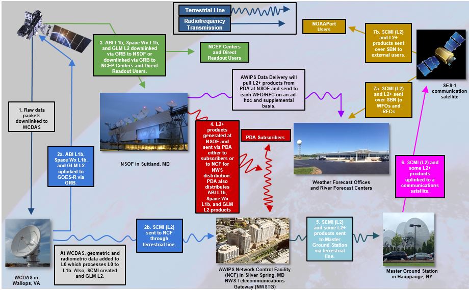
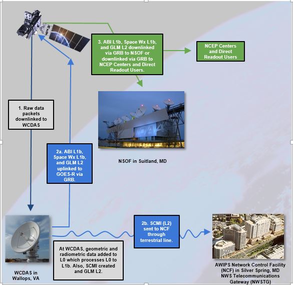
GOES Rebroadcast (GRB) enables direct broadcast users with their own receivers to receive full resolution, calibrated, near real-time direct broadcast data. These data are available to all users with GRB receivers in view of a GOES-R Series satellite at the East or West operational longitudes. GRB is the new data format for GOES-R that replaces the GOES VARiable (GVAR) service. GOES users must upgrade or acquire new antenna and receiver hardware, and acquire processing systems in order to receive the higher volume of GOES-R data via GRB.
The data available via GRB is ABI L1b, Space Weather L1b, GLM L2. NOAA Satellite Operations Facility receives the GRB data and generates the rest of the Level 2 baseline products.
GOES Rebroadcast Product Users’ Guide
GOES Rebroadcast Downlink Specifications
Satellite Receiving Equipment Manufacturers:
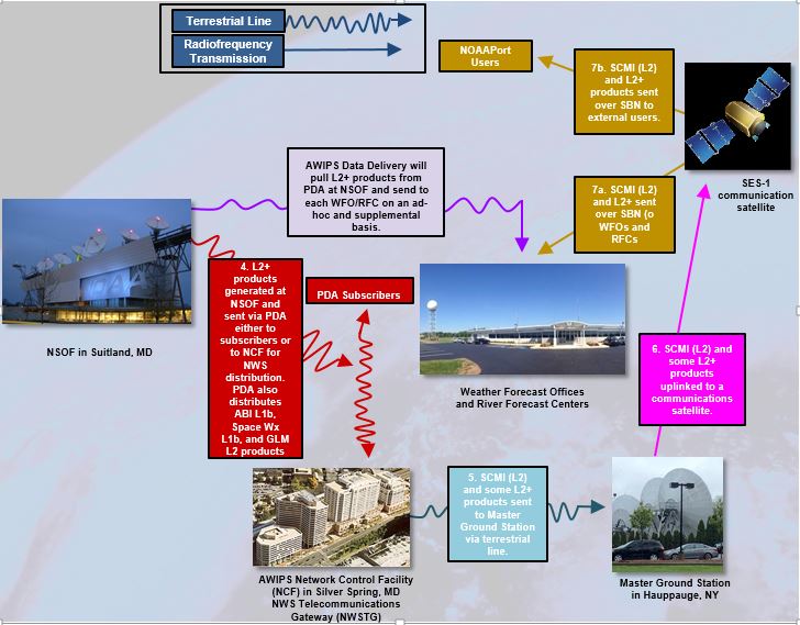
Real-time data is available to authorized users via Product Distribution and Access (PDA) which receives and stores real-time environmental satellite data and products. The Environmental Satellite Processing and Distribution System (ESPDS) is responsible for receiving and storing real-time environmental satellite data and products and making them available to authorized users.
PDA users include approved users with real-time data requirements. PDA distributes all baseline products (ABI L1b, ABI L2+, Space Weather L1b, GLM L2). What you receive depends on your subscription.
PDA replaces the current Environmental Satellite Processing Center (ESPC) systems [Data Distribution Service (DDS), NDE, GOES satepsdist, etc.] It provides a 7-day data catalog for GOES-R and supports FTPS and SFTP protocols.
Users are asked to review the policy on data access and complete a Data Access Request form. The completed Data Access Request form must be submitted to nesdis.data.access@noaa.gov. This does not guarantee access will be granted, but it is the first step in the process.
Requests from international users will be coordinated with the NOAA office of International and Interagency Affairs. Only users who demonstrate a real-time need for data will be granted access.
GOES-R Series data is also available via CLASS, the Comprehensive Large Array-data Stewardship System, a web-based data archive and distribution system for NOAA’s environmental data. CLASS will provide retrospective data access and distribution services of GOES-R data to all users.
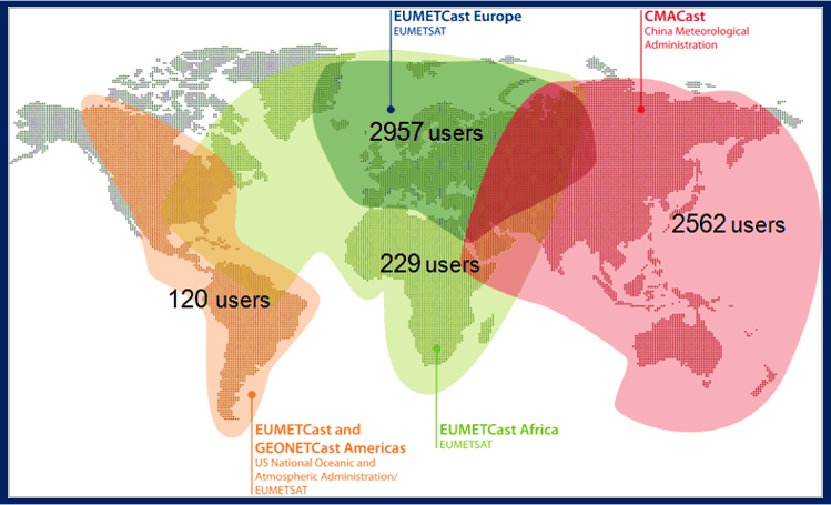
GEONETCast Americas is a commercial satellite-based, C-band broadcast of GOES-R series level 2 imagery and other products. These data are available to all users with GNC-A receivers in view of the Intelsat IS-21 satellite located at 58 degrees West Longitude.
GEONETCast-Americas serves most of North, Central, and South America including the Caribbean Basin, utilizing relatively inexpensive satellite receiver stations based on Digital Video Broadcast (DVB-S or S2) standards.
- Separate broadcast channels by data provider
- Users can choose channels they wish to receive
- Training Channel and Alert Channel Included
- No restriction on the format of products
The Advanced Weather Interactive Processing System (AWIPS) is an interactive computer system that integrates meteorological and hydrological data, enabling forecasters to prepare forecasts and issue warnings. The NWS is the primary operational user of GOES-R Series data and will receive key data directly from the GOES-R/AWIPS interface.
The Data Collection System (DCS) is a relay system used to collect information from a large number of Earth-based platforms that transmit in-situ environment sensor data on predefined frequencies and schedules, in response to thresholds in sensed conditions, or in response to interrogation signals.
The GOES-R satellite series frequency plan is different from the plan used by the GOES 13, 14 and 15 satellites. GOES Direct Readout Ground Systems (DRGS) currently support the GOES East (GOES-13) DCS downlink in the frequency range of 1694.30 to 1694.70 MHz. The GOES-R series satellites use 1679.70 to 1680.10 MHz to support the DCS downlink. GOES Data Collection System (DCS) users need to modify their Direct Readout Ground Systems (DRGS) to accommodate this change in downlink frequency, to be able to support GOES-16. Note that the GOES-16 frequency plan changes do NOT affect the Data Collection Platform (DCP) UHF-Band uplink transmissions, only the L-Band downlink to NOAA and the DRGSs. There will also be NO frequency changes in the DCS DOMSAT Ku-Band service.
The Emergency Managers Weather Information Network (EMWIN) is a direct service that provides users with weather forecasts, warnings, graphics, and other information directly from the National Weather Service (NWS) in near real time. The GOES EMWIN relay service is one of a suite of methods to obtain these data and display the products on the user’s personal computer. The HRIT (High Rate Information Transmission) service provides broadcast of low-resolution GOES satellite imagery data and selected products to remotely located user HRIT Terminals.
HRIT / EMWIN Prototype Receiver Links and Specifications


