The diversity of the JPSS user community is reflected in the wide variety and applications of JPSS data and products. Larger, institutional users can exploit the increases in spectral, temporal, and spatial resolution and assimilate radiances for use in prediction models, increasing the timeliness and accuracy of forecast products. JPSS data will be used in real time for critical life and property forecasting and warning applications primarily in the Polar Regions. Other smaller public and private sector users will be able to obtain JPSS data through their own Earth stations, or through terrestrial network distribution.
JPSS data products will be available using new product distribution and access technologies:
JPSS NUPs (NOAA Unique Products) are available from OSPO product web: http://www.ospo.noaa.gov/Products/atmosphere/soundings/nucaps/index.html
The Advanced Weather Interactive Processing System (AWIPS) is an interactive computer system that integrates meteorological and hydrological data, enabling forecasters to prepare forecasts and issue warnings. The NWS will be the primary operational user of GOES-R data and will receive key data directly from the GOES-R/AWIPS interface.
Real-time data will be available to authorized users via Product Distribution and Access (PDA) which receives and stores real-time environmental satellite data and products.
- Enterprise distribution system for real time users
- Supports only secure transfer protocols (SFTP, FTP-S and HTTPS – pull only)
- Highly automated user driven process
- User managed subscriptions, search and tailoring
- User Operational Prioritization – PDA has the ability to shed lower priority users to ensure data continuity is maintained to mission critical users
- Full policy and Data Access Request Form at OSPO
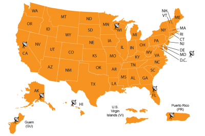
Direct readout users may utilize JPSS Direct Broadcast (DB) data in varied ways. To serve this group, JPSS has established and maintains the DB receiver specifications for interested organizations. A biennial conference with DB as a major focus functions as a critical forum for this user group to meet and discuss Direct Broadcast issues. The current antenna network providing data to NOAA’s National Center for Environmental Prediction and users worldwide includes sites in Alaska, California, Florida, Hawaii, Maryland, and Wisconsin which cover all of North America. This network of reliably positioned antennas ensures the delivery of critical data to our NWS. One of the key features of DB is that real-time imagery and selected derived products are delivered much faster to forecasters, thereby accelerating their forecasting capabilities.
DB data is processed using free open source science software through the Community Satellite Processing Package (CSPP). Once processed through the CSPP, JPSS has no direct control on how Suomi NPP and JPSS data is used. CSPP enables the creation of Level 1B and higher level products and images in real time. CSPP also provides training in local product applications to DB users of both polar orbiting and geostationary satellite data.
JPSS data can also be accessed via the University of Alaska (UA) Geographic Information Network of Alaska (GINA). GINA receives numerous geospatial data sets, many in real time.
JPSS data are accessible to public users worldwide through the NOAA CLASS, the Comprehensive Large Array-data Stewardship System in near real time (3~6 hour delay from the raw data acquisition). CLASS is a web-based data archive and distribution system for NOAA’s environmental data to scientists, researchers, and academics to review archived products (older than seven days).
Joint Polar Satellite System 1 (JPSS-1) Spacecraft High Rate Data (HRD) to Direct Broadcast Stations (DBS) Radio Frequency (RF) Interface Control Document (ICD)