Flexible Combined Imager (FCI)

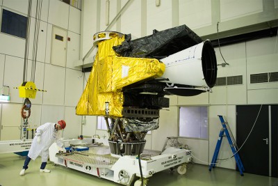
FCI instrument in at test centre. Credit: ESA
The Flexible Combined Imager (FCI) on the MTG-I satellite continues the very successful operation of the Spinning Enhanced Visible and Infrared Imager (SEVIRI) on Meteosat Second Generation (MSG).
Requirements for the FCI were formulated by regional and global Numerical Weather Prediction (NWP) and Nowcasting communities. These requirements are reflected in the design which allows for Full Disc Scan (FDS), with a basic repeat cycle of 10 minutes, and a European Regional-Rapid-Scan (RRS) which covers one-quarter of the full disc with a repeat cycle of 2.5 minutes.
The FCI takes measurements in 16 channels, of which eight are placed in the solar spectral domain between 0.4 µm to 2.2 µm, delivering data with a 1 km spatial resolution. The additional eight channels are in the thermal spectral domain between 3.8 µm to 13.3 µm, delivering data with a 2 km spatial resolution. In the RSS mode two channels in the solar domain will be disseminated with advanced spatial resolution of 0.5 km. In the thermal domain two channels will have an advanced spatial resolution of 1 km. The scanning domain is the so-called LAC4 domain, with the wider Europe region enclosed.
| Channel | Centre Wavelength | Spectral Width | Spatial Sampling Distance (SSD) |
|---|---|---|---|
| VIS 0.4 | 0.444 µm | 0.060 µm | 1.0 km |
| VIS 0.5 | 0.510 µm | 0.040 µm | 1.0 km |
| VIS 0.6 | 0.640 µm | 0.050 µm | 1.0 km; 0.5 km* |
| VIS 0.8 | 0.865 µm | 0.050 µm | 1.0 km |
| VIS 0.9 | 0.914 µm | 0.020 µm | 1.0 km |
| NIR 1.3 | 1.380 µm | 0.030 µm | 1.0 km |
| NIR 1.6 | 1.610 µm | 0.050 µm | 1.0 km |
| NIR 2.2 | 2.250 µm | 0.050 µm | 1.0 km; 0.5 km* |
| IR 3.8 (TIR) | 3.800 µm | 0.400 µm | 2.0 km; 1.0 km* |
| WV 6.3 | 6.300 µm | 1.000 µm | 2.0 km |
| WV 7.3 | 7.350 µm | 0.500 µm | 2.0 km |
| IR 8.7 (TIR) | 8.700 µm | 0.400 µm | 2.0 km |
| IR 9.7 (O3 ) | 9.660 µm | 0.300 µm | 2.0 km |
| IR 10.5 (TIR) | 10.500 µm | 0.700 µm | 2.0 km; 1.0 km* |
| IR 12.3 (TIR) | 12.300 µm | 0.500 µm | 2.0 km |
| IR 13.3 (CO2 ) | 13.300 µm | 0.600 µm | 2.0 km |
Note: The channels VIS 0.6, NIR 2.2, IR 3.8 and IR 10.5 are delivered in both FDSS and RSS sampling configurations, the latter is indicated by * in the table.

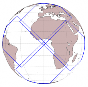
Field of view of the Lightning Imager instrument
Lightning Imager (LI)
The Lightning Imager (LI), on board the MTG-I satellites, will continuously measure at a wave-length of 777.4 nm with a very narrow bandwidth, with a spatial resolution 4.5 km at sub-satellite point, triggered by a variable threshold — optical pulses initiated by lightning emitting energy of larger than between 4 and 7 µJm-2sr-1.
The field of view (FOV) of the LI instrument is covered by four identical cameras on the instrument, each covering one out of four domains on the observable Earth disc.
Products derived from the instrument data will be arranged around following three categories:
- Events — what the instrument measures, a triggered pixel in the detector grid.
- Groups — neighbouring events in the same integration period (1 ms), representing a lightning stroke.
- Flashes — collection of groups in temporal and spatial vicinity (XX km, YY milliseconds), representing a lightning flash.
The LI will complement the two NOAA GLMs (Geostationary Lightning Mapper) on the GOES-R and the GOES-S satellites, contributing, in the long term, to near global coverage.
Infrared Sounder (IRS)

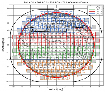
MTG Infrared Sounder dwell coverage
The IRS will deliver over the Full Disc in the Long-Wave Infrared (LWIR) 800 spectral channels and in the Mid-Wave Infrared (MWIR) 920 channels with a basic repeat cycle of 60 minutes.
The IRS is based on an imaging Fourier-interferometer with a hyperspectral resolution of 0.625 cm-1 wave-number, taking measurements in two bands, the Long-Wave Infrared (LWIR) and the Mid-Wave Infrared (MWIR), with a spatial resolution of 4 km.
Summary of technical specifications:
- Spectral bands: MWIR: 1600 to 2250 cm-1 (4.44–6.25 µm) and LWIR: 680 to 1210 cm-1 (8.26–14.70 µm).
- Full disc coverage in 60 min, Europe region (Local Area Coverage) 30 min.
- Onground resolution of 4 km x 4 km.
- Radiometric measurement ranges between 180 K and 313 K (equivalent black-body temperature.)
- Spectral radiometric noise (excluding spectral calibration) at 280 K black body: between 170 and 900 mK depending on the considered wave-number inside the band of interest
Ultraviolet Sounder

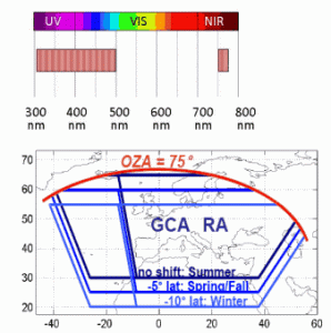
Instrument spectral bands and sampling domain
The Ultraviolet, Visible and Near-Infrared Sounding (UVN) instrument is a Copernicus Sentinel-4 instrument designed for geostationary chemistry applications. It will fly on board the MTG-S satellites
The UVN is a spectrometer taking measurements in the ultraviolet (UV: 305–400 nm), the visible (VIS: 400–500 nm) and the near infrared (NIR: 755–775 nm) with a spatial resolution of better than 10 km.
Its observations are restricted to Earth area coverage, from 30 to 65° N in latitude and 30° W to 45° E in longitude. The observation repeat cycle period will be shorter than or equal to one hour.

