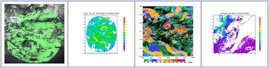
- Introductions of 4 L2 products can be seen at http://www.data.jma.go.jp/mscweb/en/product/product/index.html. The introductions for the other products are currently under preparation.
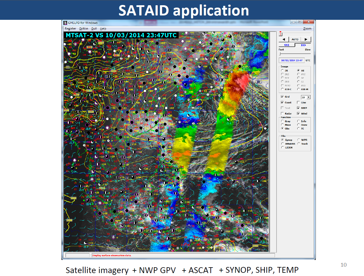
- With SATAID application, users will be able to superimpose various data and products on satellite imagery, example:
How can I use the data and products for my own application?
INSAT-3D: Data products and Applications
Data Products: Following tables show the list of data products from INSAT-3DR Imager and Sounder. These products may be updated from time to time based on user requirement and new products generated.
Products from INSAT-3D Imager
S.No. | Data Product | Processing Level | Code | Format | Remarks |
Standard Products | |||||
1 | Standard Product Full Disk | L1B | STD | HDF | Per Pixel Lat & Lon as viewed by Satellite |
2 | Standard Sector Product | L1C | Sector mnemonic | HDF | Map Projected |
Geo-Physical Parameters (Per Pixel) | |||||
1 | Outgoing long wave radiations | L2B | OLR | HDF | Per Pixel |
2 | Rainfall using Hydro Estimator | L2B | HEM | HDF | Per Pixel |
3 | Quantitative Precipitation Index (IMSRA Method) Improved | L2B | IMC | HDF | Per Pixel |
4 | Sea Surface Temperature | L2B | SST | HDF | Per Pixel |
5 | Upper Troposphere Humidity | L2B | UTH | HDF | Per Pixel |
6 | Cloud Mask | L2B | CMK | HDF | Per Pixel |
Geo-Physical Parameters (Map Projected) | |||||
1 | FOG | L2C | FOG | HDF | Map Projected |
2 | SNOW | L2C | SNW | HDF | Map Projected |
3 | INSOLATION | L2C | INS | HDF | Map Projected |
Geo-Physical Parameters (Point) | |||||
1 | FIRE | L2P | FIR | KML | Point |
2 | SMOKE | L2P | SMK | KML | Point |
3 | Visible Winds | L2P | VSW | HDF | Point |
4 | IR Winds | L2P | IRW | HDF | Point |
5 | MIR Winds | L2P | MRW | HDF | Point |
6 | WV Winds | L2P | WVW | HDF | Point |
Geo-Physical Parameters (Gridded) | |||||
1 | Quantitative Precipitation Estimate (GPI) | L2G | GPI | HDF | 1 deg x 1 deg |
2 | Aerosol Optical Depth | L2G | AOD | HDF | 0.1 deg x 0.1 deg |
3 | Quantitative Precipitation Index (IMSRA) | L2G | IMR | HDF | 0.25 deg x 0.25 deg |
Binned Geo-Physical Parameters (Temporally Binned) | |||||
1 | Outgoing long wave radiations | L3B | OLR | HDF | Daily, Weekly, Monthly and Yearly
Per Pixel |
2 | Rainfall using Hydro Estimator | L3B | HEM | HDF | Daily, Weekly, Monthly and Yearly
(Per Pixel) |
4 | Upper Troposphere Humidity | L3B | UTH | HDF | Daily, Weekly, Monthly and Yearly
(Per Pixel) |
5 | Sea Surface Temperature | L3B | SST | HDF | Daily, Weekly, Monthly and Yearly |
6 | Quantitative Precipitation Index (IMSRA Method) | L3G | IMR | HDF | Daily, Weekly, Monthly and Yearly
0.25 deg x 0.25 deg |
7 | Quantitative Precipitation Index (GPI Method) | L3G | GPI | HDF | Daily, Weekly, Monthly and Yearly
(1 deg x 1 deg) |
8 | Insolation | L3C | INS | HDF | Daily, Weekly, Monthly and Yearly (Map Projected) |
9. | Potential Evapo-Transpiration | L3C | PET | HDF | Daily, Weekly, Monthly and Yearly (Map Projected) |
Products from INSAT-3D Sounder
S.No. | Data Product | Processing Level | Code | For-mat | Remarks | |
Standard Products | ||||||
1 | Standard Product | L1B | STD | HDF | Per Pixel Lat & Lon as viewed by Satellite | |
Geo-Physical Parameters | ||||||
1 | Vertical Profiles
· Temperature Profiles (Regression and Physical Retrieval) · WV Profiles (Regression and Physical Retrieval) · Ozone Profile (Regression and Physical Retrieval) · Surface Skin Temperature (Regression and Physical Retrieval) · Total Ozone (Regression and Physical Retrieval)
Derived products · Geo Potential Height (40 levels) · Total Precipitable Water · Layer-1 (1000-900 hPa) Precipitable Water · Layer-2 (900-700 hPa) Precipitable Water · Layer-1 (700-300 hPa) Precipitable Water · Lifted Index Wind Index · Dry Microburst Index · Maximum Vertical Theta-e |
L2B | PFL | HDF | Profile on 3×3 Pixels (Average) |
Apart from these geophysical parameters the clear-sky radiances and cloud-cleared radiances from both the Imager and Sounder will be available for direct use in the radiance assimilation in NWP models.
Applications: Following is a list of the applications that is expected to benefit from the INSAT-3DR observations:
- Numerical weather prediction
- Assimilation – Radiance/Geophysical parameters
- Nowcasting – severe weather/thunderstorm/cloud-burst
- Monsoon – monitoring and assessment
- Cyclone track and intensity prediction
- Ocean State forecast
- Agricultural monitoring and forecast
- Fire monitoring
- Pollution (Dust/Haze) monitoring
- Aviation
- Ozone monitoring
- Climate applications
To leave a comment, please go to the posting details.
INSAT-3D: Software Tools and Test Data
Prior to the launch of the INSAT-3D satellite in 2013, the test data was generated using in-house developed methodology to generate proxy radiances for both Imager and Sounder from hyperspectral observation available through polar-orbiting operational satellites, such as Metop-IASI, Aqua-AIRS, and simulated radiance using NWP model analysis as input to the radiative transfer models. However, for INSAT-3DR and 3DS the situation is easier as the actual observations from INSAT-3D Imager and Sounder could work as test data as the instrument characteristic are similar and the same will be applied as the day-1 algorithm.
The software tools that were developed for INSAT-3D will work for 3DR as well as 3DS with improved features based on past few years’ experience with INSAT-3D. These software tools are integrated with the INSAT Meteorological Data Processing System (IMDPS) installed at SAC, Ahmedabad (Bopal Campus) as well as IMD, New Delhi. The processed data is archived and disseminated through Meteorological and Oceanographic Satellite Data Archival Centre (MOSDAC) at SAC.
To leave a comment, please go to the posting details.
MTG Data, Products and Applications
When released, MTG data and products generated by EUMETSAT Central Facilities, and the products generated by the EUMETSAT Satellite Application Facilities (SAF) will be available in the data catalogue of the EUMETSAT User Portal.
For more information in the MTG data release schedule see the MTG in operations user guide.
To leave a comment, please go to the posting details.