- All the distributed/disseminated Himawari-8/9 data are summarized at http://www.data.jma.go.jp/mscweb/en/himawari89/space_segment/spsg_sample.html . This table provides sample data based on actual Himawari-8 observation.
- As for the AHI Proxy data, it was calculated from NWP model data which has far coarser spatial resolution than actual atmosphere. So, the data volume could not be same as operational data theoretically. Please note that AHI proxy data volume is smaller than actual observation.
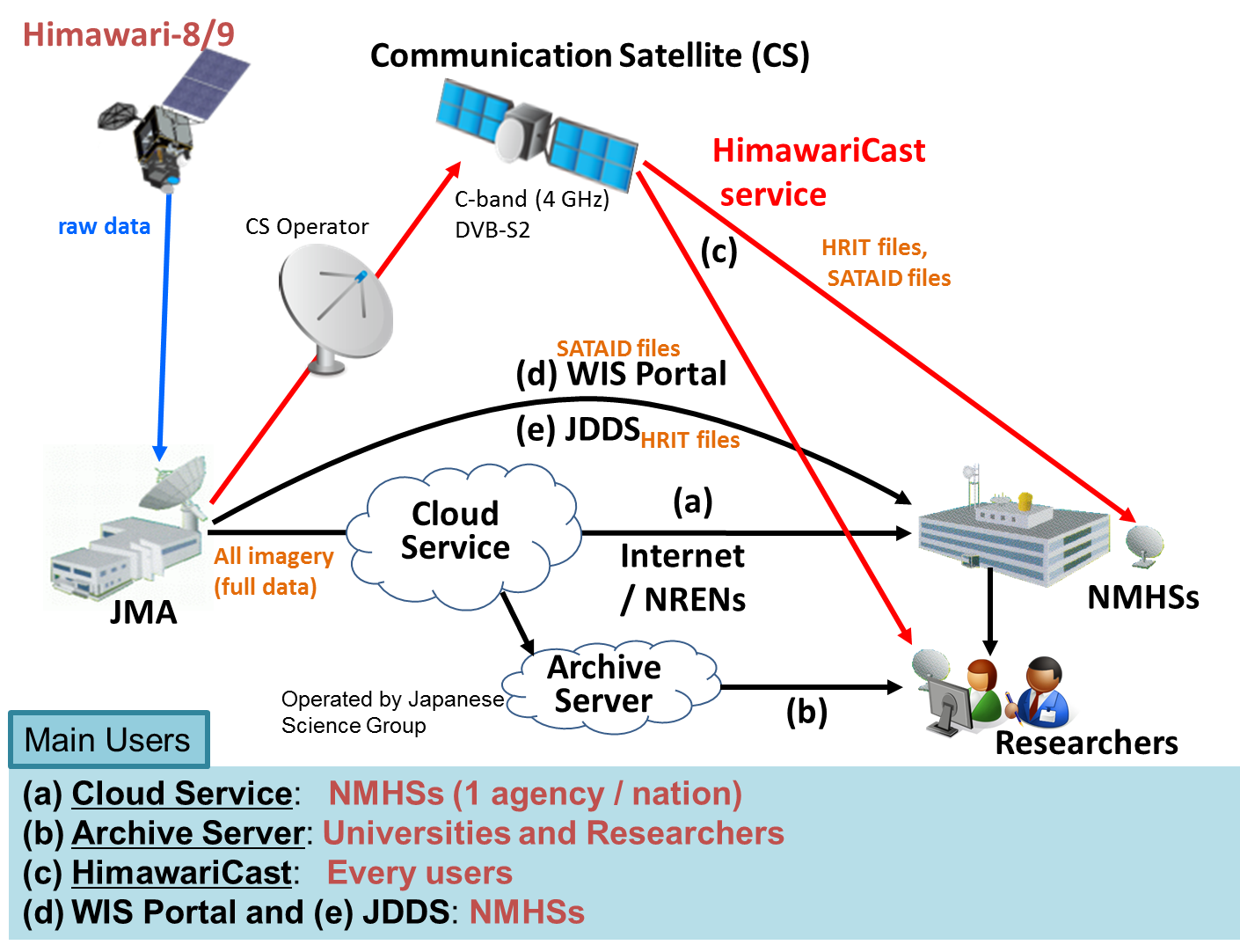
- HRIT file data described in this section will be used in dissemination via a communication satellite. This configuration is described in this figure http://www.data.jma.go.jp/mscweb/en/himawari89/fig/Overview_of_data_distribution.png.
Which formats will the data and products be in?
Himawari 8 Data Access Mechanisms
- Details on the HimawariCloud Service are available at http://www.data.jma.go.jp/mscweb/en/himawari89/cloud_service/cloud_service.html.
- Also, details of HimawariCast service including the specification of user reception systems can be found at http://www.data.jma.go.jp/mscweb/en/himawari89/himawari_cast/himawari_cast.html. HimawariCloud and HimawariCast pages will be updated with further information accordingly.
- JMA is also providing Himawari-8 data in SATAID format as JMA’s GISC portal service. You can see the details of this service at http://www.wis-jma.go.jp/cms/sataid/ and also you can download SATAID files and viewer program from this link. This SATAID service is provided for registered NMHSs.
- Current JDDS service users can continuously receive the HRIT files. The information is here.
To leave a comment, please go to the posting details.
ELECTRO-L N2 Data Formats and Volumes
The data from Electro-L N2 satellite will be distributed in HRIT/LRIT formats, as for the first satellite in series, Electro-L N1. LRIT/HRIT Mission Specific Implementation document is published at SRC Planeta WEB site, http://planet.iitp.ru/english/index_eng.htm
To leave a comment, please go to the posting details.
ELECTRO-L N2 Data Access Mechanisms
The data from Electro-L N2 satellite will be available to direct readout users in HRIT/LRIT formats after the commissioning phase completion. LRIT/HRIT Mission Specific Implementation document is published as SRC Planeta WEB-site, http://planet.iitp.ru/english/index_eng.htm. The data could also be provided in near real time by land channels to EUMETSAT for redistribution via EUMETCast.
To leave a comment, please go to the posting details.
INSAT-3D: Data Formats and Volumes
Product Format: INSAT-3DR Data will be available in CF (Climate and Forecasting) Convention version 1.6 Complaint HDF-5 format and KML (Keyhole Markup Language) for (Fire and Smoke). Providing data products in CF Complaint formats gives advantage to the users to open the products in following software makes it compatible with following freely available COTS packages:
- Ferret (v6.9) (Raster and Point Datasets) http://www.ferret.noaa.gov/Ferret/
- Grads v2.0.a8+ (Supports Gridded Products: L2G and L3G) http://www.iges.org/grads/
- MIAS (Meteorological Image Analysis Software) All Products (Indigenously Developed by SAC, ISRO)
- IDV (Integrated Data Viewer) 4.1+ (All Products) unidata.ucar.edu/software/idv
- McIDAS-V (Man Computer Interaction Data Access System) v1.3 (All Products) ssec.wisc.edu/mcidas/software/v
- HDFView 2.9 (All Products) http://www.hdfgroup.org/products/java/hdfview/
- NetCDF toolsUI.jar v4.3.22 (All Products) unidata.ucar.edu/software/netcdf-java
- Panoply v2.9.4 All Raster Products http://www.giss.nasa.gov/tools/panoply/
- Climate Data Operators (CDO) 1.6.4 rc1 (Raster Products) https://code.zmaw.de/projects/cdo
- NCAR Command Language 6.0.0 (Raster Products) ncl.ucar.edu/
- Quantum GIS 2.0.1 (as layer served by WMS) qgis.org
- THOR (Raster Products) http://pps.gsfc.nasa.gov/THOR/release.html
- ncBrowse v1.6.7 (Raster Products) ftp://ftp.epic.noaa.gov/java/ncBrowse/install.htm
Data Volume: Following Tables 5(a) & (b) shows the approximate volumes of the data products from INSAT-3DR Imager and Sounder, respectively. These volumes may change from time to time depending upon the addition/removal of a few products.
Data Volumes : INSAT-3D IMAGER
Types of Data Product | Data Volume per day |
L1B | 4.848 GB |
L02 (Sector) | 2.88 GB |
IMAGER quantitative products | 10 GB |
Total | 73 GB |
Data Volumes : INSAT-3D SOUNDER
Types of Data Product | Data Volume per day |
L1B | 9.3 MB |
SOUNDER quantitative products | 200 MB |
Total | 500 MB |
To leave a comment, please go to the posting details.
GOES-R Series Data Formats and Volumes
There are three levels of GOES-R series data:
Level 0: Unprocessed instrument data at full resolution
Level 1b: Level 0 data with radiometric and geometric correction applied to produce parameters in physical units
Level 2+: Derived environmental variables comparable to Level 1 spatial and temporal resolution
The GOES-R Product Definition and Users’ Guide (PUG) document provides a product description and format users’ guide for all data and products produced and made available to users by the GOES-R series core ground system. This includes the GOES Rebroadcast (GRB), Level 0 data, Level 1b products, and all Level 2+ end products as well as ISO series metadata, instrument calibration data and semi-static source data and algorithm packages. The PUG is divided into five volumes:
Volume 1 (Main) contains reference material, product and data overview information and cross-reference tables to specific product and data paragraphs in the other volumes.
Volume 2 (L0 Products) contains Level 0 product descriptions and format information. Note that there is an Appendix X document containing detailed descriptions of ISO series metadata associated with Level 0 products and data.
Volume 3 (L1b Products) contains Level 1b product and data descriptions and content and format information. Note that there is an Appendix X document containing detailed descriptions of ISO series metadata associated with Level 1b products and data.
Volume 4 (GRB) contains product and data descriptions and content and format information for data made available via GOES Rebroadcast (GRB). This volume also contains description, content and format information for the communications and application level protocols used in GRB. Note that there is an Appendix X document containing detailed descriptions of ISO series metadata associated with Level 1b and Level 2+ products available via GRB.
Volume 5 (Level 2+ Products) contains Level 2+ product and data descriptions and content and format information. Note that there is an Appendix X document containing detailed descriptions of ISO series metadata associated with Level 2+ products.
Appendix X (ISO Series Metadata) is an appendix to the Product Definition and Users’ Guide (PUG) containing a detailed description of the ISO series metadata.
The GOES-R Series Program has made sample datasets available that represent initial products generated from the GOES-R ground segment during integration and test of product algorithms. These datasets are intended to give GOES-R users a first look at sample data. This data is provided for reference only and should not be considered final. As the ground system is built, more sample products and updates to the data will be posted as they become available. All datasets are available in NetCDF format.
Additional test data is available through the University of Wisconsin, Madison, Space Science Engineering Center’s Community Satellite Processing Package (CSPP) for Geostationary Data. In March 2015, SSEC announced the release of the CSPP Geo GRB Prototype software package. This is the initial release of software that will allow direct broadcast users to process GOES Rebroadcast (GRB) data received on their antennas from the GOES-R satellite, after it is launched in 2016. The software is publicly available and free to use. The main functionality included in this release is to ingest a simulated GRB data stream, recover Advanced Baseline Imager (ABI) Level 1 and Geostationary Lightning Mapper (GLM) Level 2 data payloads, reconstruct the datasets, and write output to mission-standard NetCDF files.
The minimum system requirements for the CSPP Geo GRB software are:
• 12 core, 2.4 GHz CPU with 64-bit instruction support,
• 32GB RAM,
• CentOS 6 64-bit Linux (or other compatible 64-bit Linux distribution),
• 100 GB disk space
Root access may be needed on the target machine to configure network buffer settings to the recommended sizes.
A simulated ABI / GLM test case is provided, along with a test script that simulates the GRB data stream by sending UDP packets on a socket. In our internal testing, the software was able to keep up with the expected GRB data rate without packet loss when running on the recommended hardware.
To leave a comment, please go to the posting details.
MTG Data Formats and Volumes
NetCDF-4 is the baseline format for the FCI, LI and IRS instrument dataset generation. NetCDF-4 offers a number of advantageous features, including:
- Ability to cope with large dataset sizes — ~7 Gbytes for Full Disc archived dataset for MTG compared to the current ~220 Mbytes.
- Datasets are self describing.
- Groups allow potential for easier subsetting.
BUFR, GRIB and other formats will be used where there is already a product delivered in that particular format. See the Formats user guide for more details.
When available further information will be added to the Meteosat Third Generation resources section in the EUMETSAT User Portal.
To leave a comment, please go to the posting details.