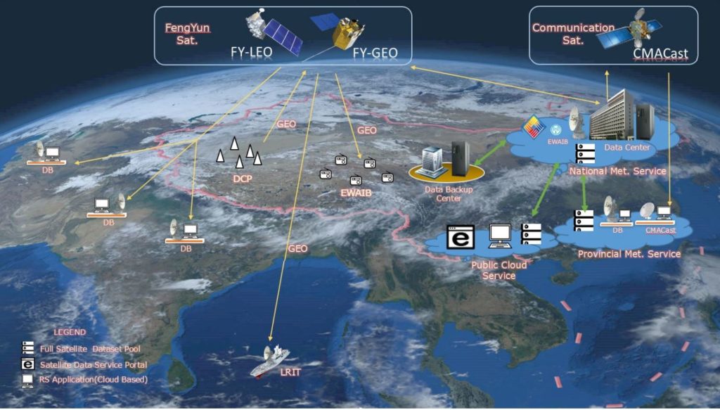
The National Satellite Meteorological Center (NSMC) was founded in 1971. It is one of the operational centers of China Meteorological Administration(CMA) and is tasked to support nation-wide weather forecasts, climate research, and natural disaster monitoring with space-based Earth Observation (EO) data and derived products.

The main responsibilities of NSMC are as follows:
- to make plan for China’s meteorological satellite development; to define user requirements for the meteorological satellite system;
- to operate the meteorological satellite system; to receive, process, archive and disseminate satellite data to end users;
- to provide information service based on meteorological satellite data for weather forecast, climate prediction, the earth environment monitoring, and space weather monitoring and warning;
- to promote nation-wide utilization of meteorological satellite data based on research on algorithms and development of products;
- to provide user with technical guidance on meteorological satellite remote sensing;
- entrusted by China Meteorological Administration, to exercise supervision and management for the implementation of satellite engineering project contracts.
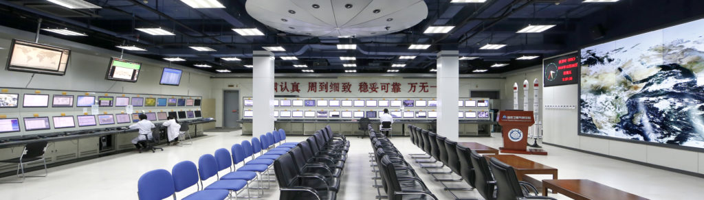
To fulfill the responsibilities, NSMC operates a number of equipments to receive, process and disseminate the meteorological satellite data. There are about 400 people working for NSM, who are engaged in system operation and maintenance, conducting research for new system establishment and application, and satellite remote sensing information service.
FY-4B: FY-4B, which is the first operational geostationary satellite in FY-4 series, was successfully launched from the Xichang Satellite Launch Center at 0:17 on June 3, 2021, and was successfully positioned over the equator at 123.5 degrees east longitude at 17:07 on June 10, 2021. There are 4 instruments on the FY-4B, Advanced Geostationary Radiation Imager (AGRI), Geostationary Interferometric Infrared Sounder (GIIRS), Geostationary High Speed Imager (GHI), and Space Environment Package(SEP).
Table . FY-4 product list.
Type | Product name | Product specifications | Format | |||||
Temporal type | Spatial resolution | |||||||
Minutely | Hourly | Daily | Ten-Daily | Monthly | ||||
Atmosphere | Aerosol optical depth | √ | √ | – | – | – | 1 km | NetCDF |
Atmospheric correction image | √ | √ | – | – | – | 1 km | NetCDF | |
Atmospheric motion vector | – | √ | – | – | – | 64 km | NetCDF | |
Convective initiation | √ | √ | – | – | – | 4 km | NetCDF | |
Fog detection | – | √ | – | – | – | 4 km | NetCDF | |
Dust detection | √ | √ | – | – | – | 4 km | NetCDF | |
Total column precipitable water | – | √ | – | – | – | 4 km | NetCDF | |
Vertical moisture profile | – | √ | – | – | – | 16 km | NetCDF | |
Vertical temperature profile | – | √ | – | – | – | 16 km | NetCDF | |
Lightning detection | √ | – | – | – | – | 78 km | NetCDF | |
Rainfall rate | √ | √ | – | – | – | 4 km | NetCDF | |
Tropopause folding | √ | √ | – | – | – | 4 km | NetCDF | |
Ocean | Sea surface temperature | – | √ | – | – | – | 4 km | NetCDF |
Cloud and radiation | All sky radiation | – | √ | – | – | – | 4 km | NetCDF |
Clear sky masks | √ | √ | – | – | – | 4 km | NetCDF | |
Clear sky radiation | – | √ | – | – | – | 4 km | NetCDF | |
Cloud optical depth | – | √ | – | – | – | 4 km | NetCDF | |
Cloud phase | √ | √ | – | – | – | 4 km | NetCDF | |
Cloud top height | √ | √ | – | – | – | 4 km | NetCDF | |
Cloud top pressure | √ | √ | – | – | – | 4 km | NetCDF | |
Cloud top temperature | √ | √ | – | – | – | 4 km | NetCDF | |
Cloud type | √ | √ | – | – | – | 4 km | NetCDF | |
Downward long wave radiation: surface | – | √ | – | – | – | 4 km | NetCDF | |
Outgoing long wave radiation | – | √ | – | – | – | 4 km | NetCDF | |
Upward long wave radiation: surface | – | √ | – | – | – | 4 km | NetCDF | |
Reflected shortwave radiation: TOA | – | √ | – | – | – | 4 km | NetCDF | |
Surface solar irradiance | – | √ | – | – | – | 4 km | NetCDF | |
Land surface | Fire/hot spot | √ | √ | – | – | – | 2 km | NetCDF |
Land surface temperature | – | √ | – | – | – | 4 km | NetCDF | |
Land surface emissivity | – | √ | – | – | – | 12 km | NetCDF | |
Note: The symbol √ means this product is available.
FY-3E:FY-3E, which is the first early-morning orbit satellite in China’s polar-orbiting meteorological satellite family, was launched on July 5, 2021. It is the first satellite of batch 03 of Chinese second-generation polar-orbiting meteorological satellite series FY-3, and it is also the world’s first civilian early-morning orbiting meteorological satellite. The design life of FY-3E is 8 years. It is equipped with 11 sets of remote sensing instruments, including: MERSI (medium resolution spectral imager), HIRAS (hyper-spectral infrared atmospheric sounder), MWTS (Micro-Wave Temperature Sounder), MWHS (Micro-Wave Humidity Sounder), GNOS (GNSS Occultation Sounder), WindRad (Wind radar), SIM (Solar Irradiance Monitor), SSIM (Solar Spectral Irradiance Monitor), XEUVI (Solar X-ray and Extreme Ultraviolet Imager), IPM (Triple-angle Ionospheric PhotoMeter), and SEM (Space Environment Monitor), among which WindRad, SSIM and XEUVI are new instruments, the MWHS is an inherited load, and the performance of 7 instruments including HIRAS has been improved.
Table . FY-3 product list.
Type | Product name | Product specifications | Format | ||||
Temporal type | Spatial resolution | ||||||
Hourly | Daily | Ten-Daily | Monthly | ||||
Atmosphere | Aerosol optical depth | – | √ | √ | √ | 1 km, 5 km | HDF5.0 |
Atmospheric Total Cloud liquid water | – | √ | √ | √ | 5 km | HDF5.0 | |
Dust storm index | – | √ | – | – | 1 km | HDF5.0 | |
Microwave rain rate | – | √ | – | √ | 25 km | HDF5.0 | |
Fog detection | – | √ | – | – | 1 km | HDF5.0 | |
Precipitation | – | √ | – | – | 1 km | HDF5.0 | |
Perceptible water | – | √ | √ | √ | 1 km, 5 km | HDF5.0 | |
Rain detection | – | √ | – | – | 15 km | HDF5.0 | |
Total ozone | – | √ | – | – | 50 km | HDF5.0 | |
Vertical humidity profile | – | √ | – | – | 33 km | HDF5.0 | |
Vertical temperature profile | – | √ | – | – | 33 km | HDF5.0 | |
Ocean | Sea surface Temperature | – | √ | √ | – | 25 km | HDF5.0 |
Sea surface wind speed | – | √ | √ | – | 25 km | HDF5.0 | |
Cryosphere | Sea ice | – | √ | √ | √ | 12 km | HDF5.0 |
Snow cover | – | √ | √ | √ | 1 km | HDF5.0 | |
Snow depth | – | √ | √ | √ | 25 km | HDF5.0 | |
Snow water equivalent | – | √ | √ | √ | 25 km | HDF5.0 | |
Cloud and radiation | Cloud amount | – | √ | √ | √ | 5 km | HDF5.0 |
Cloud mask | – | √ | 1 km | HDF5.0 | |||
Cloud optical depth | – | √ | √ | √ | 5 km | HDF5.0 | |
Cloud phase | – | √ | – | – | 1 km | HDF5.0 | |
Cloud type | – | √ | – | – | 1 km | HDF5.0 | |
Cloud top temperature | – | √ | √ | √ | 1 km, 5 km | HDF5.0 | |
Cloud top height | – | √ | √ | √ | 1 km, 5 km | HDF5.0 | |
Cloud water content | – | √ | – | √ | 25 km | HDF5.0 | |
Outgoing longwave radiation | – | √ | √ | √ | 5 km | HDF5.0 | |
Land and ecology
| Albedo | – | √ | – | – | 1 km | HDF5.0 |
Fire detection | – | √ | – | 1 km | HDF5.0 | ||
Land cover | – | – | √ | 1 km | HDF5.0 | ||
Land surface reflectance | – | √ | – | – | 250 m, 1 km, 5 km | HDF5.0 | |
Land surface Temperature | – | √ | √ | √ | 25 km | HDF5.0 | |
Fire detection | – | √ | – | 1 km | HDF5.0 | ||
Soil moisture | – | √ | √ | √ | 25 km | HDF5.0 | |
Normalized difference vegetation index | – | – | √ | √ | 250 m, 1 km, 5 km | HDF5.0 | |
Leaf area index | – | – | √ | √ | 25 km | HDF5.0 | |
Fraction of photosynthetically active radiation | – | – | √ | √ | 25 km | HDF5.0 | |
Net primary productivity | – | – | √ | √ | 25 km | HDF5.0 | |
Note: The symbol √ means this product is available.
FY-2H: FY-2H is the last one of the FY-2 series. The FY-2 spacecraft is spin-stabilized that rotates at speed of 100 r·min–1. The primary payload is a 5-channel Visible and Infrared Spin Scan Radiometer (VISSR), which takes hourly full-disk imagery of the Earth in VIS, IR, and water vapor spectral bands. At present, the operational observation position is 86.5°E.
Table: FY-2 product list.
Type | Product name | Product specifications | Format | ||||
Temporal type | Spatial resolution | ||||||
Hourly | Daily | Ten-Daily | Monthly | ||||
Atmosphere | Atmospheric motion vector | √ | – | – | – | – | HDF5.0 |
Dust detection | √ | – | – | – | 5 km | HDF5.0 | |
Precipitation estimation | √ | – | – | – | 5 km | HDF5.0 | |
Precipitation index | √ | – | – | √ | 5 km | HDF5.0 | |
Total precipitable water | √ | – | – | – | 5 km | HDF5.0 | |
Upper-tropospheric humidity | √ | – | – | – | 5 km | HDF5.0 | |
Ocean | Sea surface temperature | √ | √ | √ | √ | 5 km | HDF5.0 |
Cryosphere | Snow cover | √ | – | √ | – | 5 km | HDF5.0 |
Cloud and radiation | All sky radiation | √ | – | – | – | 5 km | HDF5.0 |
Blackbody brightness temperature | √ | √ | √ | √ | 5 km | HDF5.0 | |
Clear sky radiation | √ | – | – | – | 5 km | HDF5.0 | |
Cloud classification | √ | – | – | – | 5 km | HDF5.0 | |
Cloud detection | √ | – | – | – | 5 km | HDF5.0 | |
Cloud top temperature | √ | – | – | – | 5 km | HDF5.0 | |
Cloud total amount | √ | – | – | – | 5 km | HDF5.0 | |
Outgoing Long wave Radiation | √ | √ | √ | √ | 5 km | HDF5.0 | |
Surface solar irradiance | √ | – | – | – | 5 km | HDF5.0 | |
Land and ecology | Land surface temperature | √ | √ | √ | √ | 5 km | HDF5.0 |
Note: The symbol √ means this product is available.
- 1 Nov. 2021 – 5 Nov. 2021, 11TH ASIA-OCEANIA METEOROLOGICAL SATELLITE USERS’ CONFERENCE (AOMSUC-11) AND 2021 FENGYUN SATELLITE USER CONFERENCE(FYSUC-2021)
- 29 Oct. 2021, Joint China Austrilia Vlab Centers of Excellence Regional Focus Group meeting
- 8 Jun. 2021, Joint China Austrilia Vlab Centers of Excellence Regional Focus Group meeting
- 26 Apr. 2022, Joint China Austrilia Vlab Centers of Excellence Regional Focus Group meeting
Sat Op Contact Information

Dr. WANG Jinsong
Sat Op Director

Mr. XIAN Di
Sat Op VLab Point of Contact